Nildelta
Bildinfo und Lizenz
© 2016
- 2026
Bildinfo
- Das grüne Nildelta: der Name Delta stammt von der dreieckigen Form des großen griechischen Buchstaben Delta. Von unten nach oben fließt der Nil mit seinen begrüntem Uferbereich. Wo er sich zum Delta weitet liegt die Stadt Kairo. Am rechten Rand sieht man den Suezkanal, der das Mittelmeer oben mit dem Roten Meer unten verbindet.
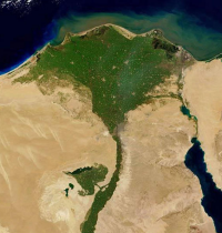
- In this picture the Nile River runs north to the edge of the Mediterranean Sea, where it widens out into a vast delta. Just at the apex of the delta is the ancient city of Cairo. The city appears as a gray spot sandwiched between the delta and the northern end of the Eastern Desert. The leaf-shaped patch of green branching off of the left (western) side of the Nile Valley is a depression in the Libyan Desert that has been used as an irrigated agricultural area since 1800 BC, when the original irrigation canals were dug. The depression is fertilized by the Nile's water and silt.
Source
- Created: January 6th, 2021
- Author: Jacques Descloitres
- Credit: MODIS Land Rapid Response Team, NASA/GSFC
License
- All images provided by the USGS are in the Public Domain unless otherwise stated.
Warranty
- No guarantee can be given as to the correctness of facts implied or explicitly stated.
- Usage is completey at your own risk. 💣
Originalseite
- Das Bild ist Teil eines online-Lexikons.
- Rhetos Lernlexikon Mathematik, Aachen:
- Siehe unter 👉 Nildelta