Muschelprobe Mellum
Bildinfo und Lizenz
© 2016
- 2026
Bildinfo
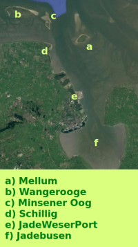
- Mellum ist die mit a markierte Insel. Das erstreckt erstreckt sich von Norden nach Süden über rund 40 km: a ist Insel Mellum, b ist die Insel Wangeooge, c ist die unbewohnte Insel Minsener Oog, d ist der Urlaubsort Schillig, e ist der JadeWeserPort und f ist der Jadebusen.
Source
- Author: Ansicht aus Google Maps, 2021
- Date: August 21st, 2021
License
- Auszug des originalen Google-Lizenz-Textes vom 28. März 2020: "Subject to your compliance with this Agreement's terms, Google grants you a non-exclusive, non-transferable license to use Google Maps/Google Earth, including features that allow you to: view and annotate maps; create KML files and map layers; publicly display Content with proper attribution online, in video, and in print ... "
Warranty
- No guarantee can be given as to the correctness of facts implied or explicitly stated.
- Usage is completey at your own risk. 💣
Originalseite
- Das Bild ist Teil eines online-Lexikons.
- Rhetos Lernlexikon Mathematik, Aachen:
- Siehe unter 👉 Google Maps