Flächenversiegelung
Bildinfo und Lizenz
© 2016
- 2026
Bildinfo
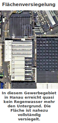
- Gewerbegebiete sind eine sehr effektive Maßnahme zur Flächenversiegelung.
- Der Bildausschnitt entspricht einer Länge von rund 316 Metern.
- Man sieht einen (kleinen) Ausschnitt aus einem Gewerbegebiet.
- Das Gewerbegebiet liegt nördöstlich des Hauptbahnhofes Hanau.
- Die Straße links im Bild ist die Freigerichtstraße in Hanau.
- Die Aufnahme stammt aus dem Online-Dienst Google Maps.
Source
- Author: Ansicht aus Google Maps, 2020
- Date: November 22nd, 2020
License
- Auszug des originalen Google-Lizenz-Textes vom 28. März 2020: "Subject to your compliance with this Agreement's terms, Google grants you a non-exclusive, non-transferable license to use Google Maps/Google Earth, including features that allow you to: view and annotate maps; create KML files and map layers; publicly display Content with proper attribution online, in video, and in print ... "
Warranty
- No guarantee can be given as to the correctness of facts implied or explicitly stated.
- Usage is completey at your own risk. 💣
Originalseite
- Das Bild ist Teil eines online-Lexikons.
- Rhetos Lernlexikon Mathematik, Aachen:
- Siehe unter 👉 Flächenversiegelung
External images
- Parkplatzruine I: https://commons.wikimedia.org/wiki/File:Flächenversiegelung_(Dörnigheim,_Germany).jpg
- Parkplatzruine II: https://commons.wikimedia.org/wiki/File:Flächenversiegelung_(Dörnigheim,_Germany).jpg
- CDU-Auto-Landschaft: https://commons.wikimedia.org/wiki/File:CDU_Wahlkampfplakat_-_kaspl024.JPG
- Horizontfläche: https://commons.wikimedia.org/wiki/File:Globalmaschine_(Sande,_Horizontversiegelung).jpg
- Hafenfläche 2013: https://commons.wikimedia.org/wiki/File:Imagedrohne.com_Geniusstrand_Luftbild_-_panoramio.jpg
- Hafenfläche 2023: https://commons.wikimedia.org/wiki/File:Globalmaschine_(JadeWeserPort_Logistikzentrum_P3).jpg