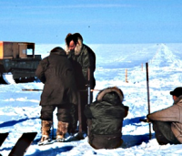
 Geodäten messen lange Streckenzüge in der Arktis (Kanada). Um Messungenauigkeiten und Zufallseinflüsse zu minimieren kombiniert man Ergebnisse aus Satellitenbeobachtungen, Überfliegungen und land- oder seegestützten Vermessungen.
© Rear Admiral Harley D. Nygren => Zurück zum Artikel
Geodäten messen lange Streckenzüge in der Arktis (Kanada). Um Messungenauigkeiten und Zufallseinflüsse zu minimieren kombiniert man Ergebnisse aus Satellitenbeobachtungen, Überfliegungen und land- oder seegestützten Vermessungen.
© Rear Admiral Harley D. Nygren => Zurück zum Artikel
Geodäsie
Bildinfo und Lizenz
Bildinfo
- Geodäten messen lange Streckenzüge in der Arktis (Kanada). Um Messungenauigkeiten und Zufallseinflüsse zu minimieren kombiniert man Ergebnisse aus Satellitenbeobachtungen, Überfliegungen und land- oder seegestützten Vermessungen.
- NOAA-Description: Baseline measurements on the lagoon ice - note stakes along line
- Location: Alaska North Slope, 1950
- Das Bild ist gegenüber dem Original von links nach rechts gespiegelt.
Source
- Date: Spring 1950
- Author: Rear Admiral Harley D. Nygren
- Credit: NOAA Corps (ret.)
License
Images in the NOAA Photo Library are in the public domain and cannot be copyrighted. There is no fee for downloading any images on the site. Educational use is encouraged as the primary goal of the NOAA Photo Library is to help all understand our oceans and atmosphere.
Originalseite
- Das Bild ist Teil eines online-Lexikons.
- Rhetos Lernlexikon Mathematik, Aachen:
- Siehe unter => geodaesie